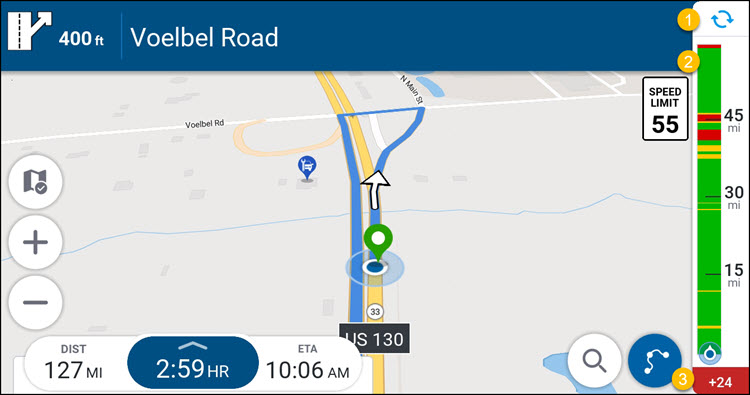
The traffic bar
When you are navigating, CoPilot will display the traffic bar, which is a color-coded representation of traffic conditions on your route.
-
Green = traffic flow is normal, no unusual slow down
-
Yellow = slow moving traffic but still flowing
-
Red = standstill with bigger impact on travel time/ETA
-
Black = A road segment is completely closed. In this case, CoPilot will attempt to calculate an alternative route.
|
If you have more than one stop planned in your trip, traffic information is only shown for the route to the next (upcoming) stop. For example, once you have reached your first stop and begun your journey to the second stop, traffic information will be displayed for the second stop, and so on. |
The example below shows a 127-mile trip. The distance bar can show traffic information up to 60 miles/90 kilometers from your current location. (Traffic information beyond 60 miles from your current location will most likely change before your arrival, and so is not displayed.)
The total distance shown will be either 60 miles (if your destination is more than 60 miles away) or the remaining distance to your next destination.
-
The traffic bar will automatically refresh every few minutes. To manually refresh the data, tap the refresh button at the top of the bar.
-
If there are traffic incidents at your destination, as you get closer to the destination, the traffic bar will start to show a bigger yellow / red indication. This doesn’t mean the traffic has suddenly increased, just that the distance remaining is getting shorter and so the traffic incidents take up more of the remaining route. The bottom of the bar includes your vehicle chevron. This always remains at the bottom to indicate the remaining route.
-
The figure at the bottom of the traffic bar represents the number of minutes’ delay to your journey, based on current traffic conditions.
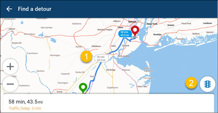
View alternative routes
(First available in CoPilot 11.2)
If you want to see alternative routes while navigating, tap the traffic bar. This opens the Find a detour screen, where you can see up to three alternative routes, along with their estimated travel time and distance.
-
Tap any of the routes to select it, and CoPilot will recalculate your route accordingly.
-
Tap the street light icon and zoom in on the map to see current traffic conditions.
After selecting a route, tap Go to begin navigating the new route.