PCMiler
how to search

PCMiler

  • Get Started
    • About the PC*Miler User Guide
    • What can you do with PC*Miler?
    • PC*Miler Premium Add-Ons
    • Help in PC*Miler
  • Installation
    • General Licensing Information
    • Do I Need to Uninstall Old PC*Miler Versions?
    • How to Unzip a PC*Miler Download
    • PC*Miler 39 Hardware and Software Requirements
    • Installation Types
    • Important Installation Notes
    • Single User Local (Non-Network) Installation
    • Multi-User Network Installation
    • Silent Installation
    • Citrix and Terminal Services Installations
    • Install Data Add-ons
    • Disabling Licensed Features (Enterprise License Only)
    • Activating Using a Proxy Server
    • Installing Additional Licensed Products
    • Deactivating, Uninstalling and Transferring a License
    • Remote Support and License Tools
    • Importing Settings From a Previous Version
  • Application Settings
    • Application Settings
    • Application Settings > General
    • Application Settings > Fuel Prices
    • Application Settings > Custom Content
    • Application Settings > Geocoding
    • Application Settings > Map
    • Application Settings > Proxy Internet Access
    • Application Settings > Report
    • Application Settings > Road Speeds
    • Application Settings > Route Costs
    • Application Settings > Tolls
    • Application Settings > Units of Measurement
    • Application Settings > Weather
    • Application Settings > Worldwide
    • PC*Miler Shortcut Keys
    • Worldwide Postal Code Formats
    • PC*Miler Default Road Speeds
    • The PCMSERVE.INI file (PC*Miler Connect and Spreadsheets)
  • Map and Display Settings
    • Home Screen
    • Window and Layout Options
    • Route Window Display Options
    • Quick Access Toolbar
    • Location Radius Search
    • Map Window
    • Frame a Map Location
    • Drag or Pan the Map View
    • Weather Information & Alerts
    • Weather Settings and Display
    • Zoom In on a Map Location
    • Map Legends
    • Hide and Display Map Features
    • Map Styles
    • Right Mouse Map Menu
    • Route Framing on the Map
    • Route Distances and Drive Times on the Map
    • Print or Copy a Map
  • Routing
    • How PC*Miler Distances are Calculated
    • The Route Window
    • Entering Stops for a Route
    • Editing the Stop List
    • Quickly Adding Multiple Stops to a Route
    • Stop Formats in PC*Miler
    • Address Entry (Streets add-on required)
    • Using the Pick List
    • Running a Route
    • Running a Route With ETA/ETD
    • Finding the Best Route: Using Via Points
    • Finding the Best Route: Comparing Routes
    • Finding the Best Route: Dragging a Route on the Map
    • “Special Restrictions” in Routing and Reports
    • Finding the Best Route: Stop Optimization
    • PC*Miler Least Cost Routing
    • Hub Routing
    • Routing For Different Vehicle Sizes and Restriction Overrides
    • Overriding Truck-Restricted Roads
    • Loaded/Empty Stop Designation
    • Setting a Governor Speed
    • Route Window Warnings
    • Saving and Retrieving Trips
    • Border Crossings (U.S. only)
    • PC* Miler Road Classifications
    • City Name and State/Country Abbreviation
    • Entering ZIP/Postal Codes
    • Highway Junctions (North America only)
    • Canadian Postal Codes in PC*Miler
    • SPLC Entry (North America only)
    • Picking Stops from the Map
    • Latitude/Longitude Points
    • Latitude/Longitude With Street Address
    • Highway Exits (U.S. only)
    • CAT Scale Weigh Stations (U.S. and Canada only)
    • Truck Stops (U.S. and Canada only)
    • State Weigh Stations (U.S. only)
    • Entering Mexican and Canadian Locations
  • Route Options
    • Setting Route Types & Options
    • Route Options
    • Changing the Region (PC*Miler Worldwide and DTOD Data only)
    • Changing the Map Data Set
    • Rating with PC*Miler: Choosing a Data Set
    • Route Profiles: Overview
    • Route Profiles: The Default Rating Profile
    • Route Profiles: Creating a New Profile
    • Route Profiles: Editing an Existing Profile
    • Route Profiles: Managing Profiles
    • Route Profiles: Selecting a Profile
    • Route Profiles: Preset Profiles
    • Route Profiles: Profile Options
    • Vehicle Dimensions
    • Routing Preferences
    • Reporting Preferences
    • Automobile Routing
    • PC*Miler Route Types
    • PC*Miler Practical Routes
    • PC*Miler Shortest Routes
    • PC*Miler Fastest Routing (North America only)
    • PC*Miler State + National Network Routes (U.S. only)
    • PC*Miler Toll Discouraged Routes
  • Traffic, Tolls, and Hazmats
    • Use Traffic Data for Route Planning (U.S. and Canada only)
    • Traffic Settings and Display
    • Hazmat Routing
    • U.S. DOT Hazmat Classes and Hazmat Route Types
    • Routing Multiple Hazmat Classes
    • Hazardous Material Routing on the Map
    • Get Toll Costs (U.S. and Canada only)
    • Toll Cost Settings and Display
    • Toll Information in the State/Country Report
    • Get Toll Totals in the Comparison Report
  • Reports
    • Report Types
    • Font Size and Page Layout
    • Report Windows
    • Mileage Report
    • Detailed Report
    • State/Country Report
    • Driver’s Report (Directions)
    • Road Type Report
    • Comparison Report
    • Weather Reports
    • ETA/ETD in Reports
    • Print Reports
    • Save and Copy Reports
  • Tools
    • PC*Miler State/Province/Estados Abbreviations
    • PC*MILER and ContentTools
    • PC*Miler Users: Signing up for Content Tools
    • PC*Miler Users: The Content Tools Menu
    • Using Places in PC*Miler
    • Using Sites in PC*Miler
    • Using Route Modifiers in PC*Miler
    • Places Search (U.S. & Canada only)
    • Using MapSure
    • Finding Places on the Map (U.S. only)
    • Creating a Geofence
    • Customizing Geofence Sets
    • Importing Geofences
    • Identify Locations Within a Geofence Boundary
    • Geofence Report
    • Country Codes for Worldwide Regions
    • Mexican Estados Abbreviations
  • Trip Management
    • Hours of Service (HOS) Trip Management (U.S. only)
    • HOS Manager Notes
    • Search for Fuel Stops and Prices (U.S. & Canada only)
    • Add Stop Durations
  • Spreadsheets
    • What is PC*Miler Spreadsheets?
    • Spreadsheets Requirements, Installation and Licensing
    • Demo Spreadsheets
    • The Spreadsheets Excel Add-In: Enabling and Disabling
    • Spreadsheets: Entering Formulas
    • Spreadsheets: Entering Locations
    • Spreadsheets: Set Routing Options (PCMSERVE.INI)
    • Spreadsheets: Get Mileage
    • Spreadsheets: Get the Drive Time
    • Spreadsheets: Postal Codes
    • Spreadsheets: SPLCs as Stops
    • Spreadsheets: Latitude/Longitude Points as Stops
    • Spreadsheets: Worldwide Data
    • Spreadsheets: Location Names with Special Characters
    • Spreadsheets: Multi-Stop and Hub Routes
    • Spreadsheets: Change Route Options
    • Using Spreadsheets: Toll Costs
    • Spreadsheets: Combination Routing
    • Spreadsheets: Get Location Information (Postal Codes)
    • Spreadsheets: Get Location Information (Names)
    • Using Spreadsheets: Get Location Information (Lat/Long)
    • Spreadsheets: Sites Routing
    • Spreadsheets: Get State/Country Distances with Tolls
    • Spreadsheets: Avoid, Favor or Override Roads
    • Spreadsheets: HazMat Routing
  • BatchPro
    • Overview, Requirements and Installation
    • BatchPro: The Main Window
    • BatchPro: Create an Input File
    • BatchPro: Format SPLC Input Files
    • BatchPro: Select Mexican Postal Codes
    • BatchPro: Select an Input File
    • BatchPro: Create or Select a File Format
    • BatchPro: Set Route Options
    • BatchPro: Output Files
    • BatchPro from the Command Line
    • BatchPro: Errors in Log Files
    • BatchPro: Fatal Errors
  • AS/400
    • AS/400 Introduction
    • Installation: AS/400 Side
    • AS/400 Installation: PC Side
    • AS/400 Installation: Upgrading from Past Versions
    • AS/400 Installation: Desktop Icons
    • AS/400 Settings: Start or Stop the Mileage Server
    • AS/400 Settings: Mexican Postal Codes
    • AS/400: The Main Screen
    • AS/400: Function Keys
    • AS/400: Basic Mileage, Cost and Time Report
    • AS/400: State Mileage Report
    • AS/400: Driving Directions
    • AS/400: Menus
    • AS/400: Configuring Client Access Express
    • AS/400: Sleep Feature for Connection/IPL Issues
    • AS/400: PCMSERVE.INI Settings
  • Geocode Files
    • What are PC*Miler Geocode Files?
    • Asia, Africa, Middle East, South America, and Oceania City and Postal Code File
    • Asia, Africa, Middle East, South America, and Oceania City and Postal Code File with Latitude/Longitude Coordinates
    • Canadian Postal Code File
    • Canadian Postal Code File with Latitude/Longitude Coordinates
    • Europe City and Postal Code File
    • Europe City and Postal Code File with Latitude/Longitude Coordinates
    • North America City and ZIP-Postal Code File
    • North America City and ZIP-Postal Code File with Latitude/Longitude Coordinates
    • North America City, ZIP-Postal Code, and SPLC File
    • North America City, ZIP-Postal Code, and SPLC File with Latitude/Longitude Coordinates
    • North America U.S. PO Box ZIP Code File
  • Release Notes
    • What’s new in PC*Miler 39? (Version release notes)
    • PC*Miler 38 Software Patch - October 2024
    • PC*Miler 38: Updates and Patches
    • What’s new in PC*Miler 38?
    • PC*Miler 37: Updates and Patches
    • PC*Miler 37 Software Patch - October 2023
    • What’s new in PC*Miler 37 (version release notes)
  • FAQs
    • What is PC*Miler?
    • Custom Data
      • Backing Up Your Custom Files (Strongly Suggested)
      • Why do I get an Invalid P.O. Box error?
      • Export Custom Places
      • Export Custom Roads
    • Application
      • How do I download the latest version?
      • How do I add street level or international map data?
      • Which operating systems support PC*Miler?
      • How do I add new features?
      • Which PC*MILER products have been discontinued?
      • How do I turn off PC*Miler notifications?
      • Is PC*Miler available via APIs?
      • How do I add a zoom bar to my PC*Miler Map?
    • Installation
      • Why do I get an 'Access is denied (0x5)' or 'Feature transfer error' pop-up during installation?
    • Map and Routing Data
      • Does PC*Miler offer worldwide data?
      • Does map data change when a new version of PC*Miler releases?
      • Can PC*Miler map data be licensed separately for other uses?
      • Routing enhancement to improve accuracy of estimated travel times
      • ZIP Codes and Postal Codes
      • Why can’t I find a street address in PC*Miler?
      • How should I format a street address in PC*Miler?
      • Why don’t I see any streets?
      • How do I report a data or map error?
    • AS/400
      • PC*Miler AS/400: How do you delete temporary data queues?
      • How do I install the AS/400 library after downloading?
    • Routing
      • Why is latitude/longitude decimal precision important?
      • Can I use 3-digit ZIP codes with Spreadsheets?
      • Which roads are considered urban or rural when setting road speeds?
    • Tolls
      • Do toll costs take time/day into account?
      • Why is $0 returned for tolls?
    • Spreadsheets
      • Spreadsheets Common Errors and Questions
  • Troubleshooting
    • Contact technical support
    • License Errors
      • -706 or -715 error
      • -712 or -734 error
      • User Count Exceeded error
      • -707 error
      • -710 error
      • -105 to -132 errors
      • My Multi-user network license
    • Spreadsheet Errors
      • What does 'Error 1004: Programmatic access to Visual Basic Project is not trusted' mean?
      • Why do Excel cells show '#NAME?'?
      • Microsoft Excel Error 453
    • User Interface Errors
      • Fatal Exception After 2021 Microsoft .NET Updates
      • Internet connectivity error
      • What does 'Your license is currently valid' mean?
      • Error when closing PC*Miler
      • What do I do when my map disappears?
      • I receive an "ALK Login Error" when using my ALK ID
      • Why is my local PC*Miler client loading slowly?
    • AS/400 Errors
      • AS/400: Troubleshooting
      • AS/400: AS400.LOG Error Codes
  • PCMiler
  • Troubleshooting
  • User Interface Errors
  • What do I do when my map disappears?

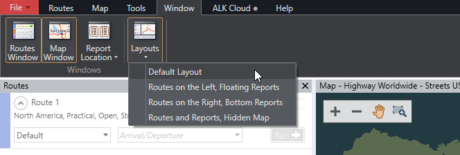
What do I do when my map disappears?

To re-open the Map Window, select the Window tab >  Layouts > Default Layout.

mROnDvrd49JTSyTjeSFs5ncgBmrfRpaosg

Error when closing PC*Miler I receive an "ALK Login Error" when using my ALK ID
×
×